Physical geology is the study of Earth’s physical structure‚ composition‚ and processes. It examines rocks‚ minerals‚ and landforms to understand the planet’s dynamics and history. This introduction provides an overview of key concepts‚ methods‚ and tools used in physical geology‚ emphasizing its relevance to natural resources‚ environmental challenges‚ and everyday life. By exploring geological principles‚ students gain practical skills and insights into Earth’s systems and materials.
1.1 What is Physical Geology?
Physical geology focuses on the study of Earth’s physical structure‚ composition‚ and processes. It explores the formation and properties of rocks‚ minerals‚ and landforms‚ providing insights into the planet’s evolution. This field combines laboratory and fieldwork to analyze geological materials and phenomena‚ emphasizing practical applications in natural resource management‚ environmental sustainability‚ and understanding Earth’s systems. By examining the interplay of geological processes‚ physical geology bridges scientific theory with real-world challenges‚ offering essential knowledge for addressing societal and environmental issues.
1.2 Importance of Laboratory Work in Physical Geology
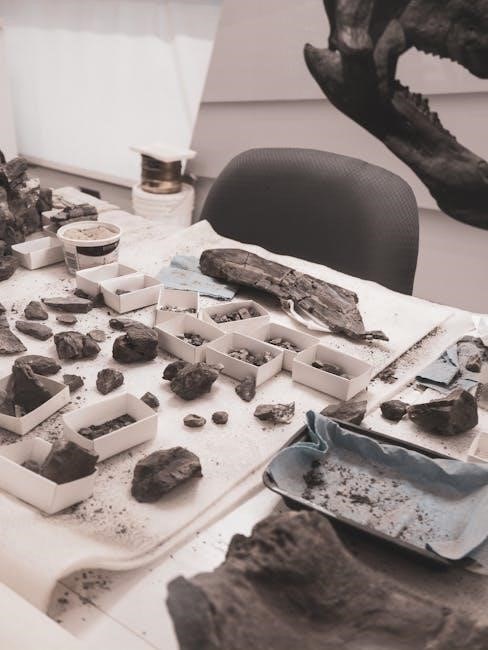
Laboratory work is essential in physical geology as it provides hands-on experience in observing‚ analyzing‚ and interpreting geological materials. Through lab exercises‚ students develop practical skills in identifying minerals and rocks‚ understanding their properties‚ and applying scientific methods. Lab work enhances critical thinking and problem-solving abilities‚ preparing students for real-world applications in resource exploration‚ environmental management‚ and hazard assessment. By engaging with specimens and data‚ learners gain a deeper understanding of Earth’s systems and processes‚ making laboratory work a cornerstone of geological education.
Identifying Minerals
Identifying minerals involves examining their physical properties and chemical reactions. Key tests include hardness‚ streak‚ density‚ and acid reactions to determine mineral species accurately.
2.1 Mineral Properties: Hardness‚ Streak‚ and Density
Mineral identification relies on key physical properties: hardness‚ streak‚ and density. Hardness‚ measured on the Mohs scale‚ indicates resistance to scratching. Streak‚ the color produced when a mineral is powdered‚ helps distinguish similar species. Density‚ the mass per unit volume‚ is calculated by measuring weight and volume. These properties‚ along with others like luster and cleavage‚ provide critical data for accurate mineral identification. Understanding and testing these properties is essential for geology students to develop practical laboratory skills and confidently identify mineral samples.
2.2 Chemical Tests for Mineral Identification
Chemical tests are crucial for identifying minerals when physical properties are inconclusive. Common tests include acid reactions‚ such as dilute hydrochloric acid on carbonate minerals‚ which produce effervescence. Streak tests on porcelain plates can reveal chemical composition. Reagents like nitric acid or aqua regia are used to test for sulfides or noble metals. These tests provide direct evidence of a mineral’s chemical makeup‚ aiding in accurate identification. By combining chemical and physical properties‚ geologists can confidently determine mineral species and their compositions.

Classifying Igneous‚ Sedimentary‚ and Metamorphic Rocks
Rocks are classified into igneous‚ sedimentary‚ and metamorphic based on mineral composition‚ texture‚ and formation processes. This system helps understand their origin and geological significance.
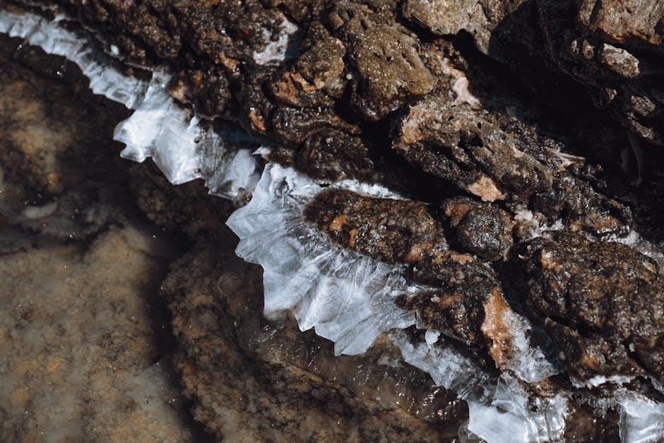
3.1 Characteristics of Igneous Rocks
Igneous rocks form from cooled magma or lava‚ exhibiting unique textures and compositions. They are classified as intrusive (slow-cooled‚ large crystals) or extrusive (fast-cooled‚ small crystals). Their mineralogy reflects magma composition‚ ranging from felsic (high silica) to mafic (low silica). Textures vary‚ including phaneritic‚ aphanitic‚ porphyritic‚ and vesicular. These rocks provide insights into magmatic processes and Earth’s thermal history‚ aiding in laboratory identification and geological interpretations.
3.2 Distinguishing Sedimentary and Metamorphic Rocks
Sedimentary rocks form from compressed sediments‚ often showing layering or fossils‚ while metamorphic rocks develop from altered pre-existing rocks under high pressure and temperature. Sedimentary rocks may contain mineral grains or organic material‚ while metamorphic rocks exhibit recrystallized minerals and textures like foliation. Laboratory identification involves observing features such as bedding in sedimentary rocks and cleavage patterns in metamorphic rocks. These distinctions are crucial for understanding Earth’s history and geological processes‚ aiding in accurate classification and analysis in physical geology studies.

Geological Maps and Tools
Geological maps depict Earth’s surface features‚ aiding in understanding rock distributions and structural relationships. Tools like the Brunton compass and stereo microscopes enhance field and laboratory analysis‚ ensuring precise data collection and interpretation for geological studies.
4.1 Reading and Interpreting Geological Maps
Reading geological maps involves interpreting symbols‚ colors‚ and patterns to understand Earth’s surface features. These maps depict rock types‚ structural data‚ and geological events. Key elements include legends‚ scales‚ and grid systems. By analyzing map symbols and colors‚ one can identify mineral deposits‚ fault lines‚ and sedimentary layers. Geological maps are essential for fieldwork‚ resource exploration‚ and environmental studies. They provide insights into Earth’s history and help predict future geological events. Practice and correlation with real-world data enhance interpretation skills‚ making geological maps indispensable tools for geologists.
4.2 Using a Stereo Microscope for Mineral Analysis
A stereo microscope is a key tool in mineral analysis‚ providing a three-dimensional view of specimens. It uses two separate optical paths to create depth perception‚ allowing detailed examination of mineral textures and structures. The stereo microscope is particularly useful for studying small-scale features‚ such as crystal habits and cleavage patterns. With adjustable magnification and illumination‚ it enhances the ability to identify minerals and rocks. Regular use in laboratory and field settings makes it an essential instrument for geologists to analyze specimens effectively and accurately.

Practical Skills in Geological Laboratory Work
Practical skills in geological laboratory work involve measuring and interpreting geological features. Tools like Brunton compasses and stereonets aid in analyzing rock structures and orientations.
5.1 Measuring Geological Features: Strike and Dip
Measuring geological features like strike and dip is essential for understanding rock orientations. Strike refers to the horizontal direction of a rock layer‚ while dip indicates its angle downward. Using tools like a Brunton compass‚ geologists record these measurements to analyze structural geology. Accurate data helps in mapping folds‚ faults‚ and layered sequences. Proper techniques ensure reliable results‚ crucial for interpreting geological histories and understanding Earth’s internal processes. These skills are vital for fieldwork and laboratory analysis in physical geology studies.
5.2 Using a Brunton Compass for Field Measurements
The Brunton compass is a portable‚ durable tool used for precise field measurements. It measures strike‚ dip‚ and trend of geological features. To ensure accuracy‚ the compass must be properly leveled. The clinometer is used to measure the angle of dip‚ while the base plate provides a stable surface. Regular calibration and care are essential for maintaining reliability. Proper handling ensures consistent and precise data collection‚ making the Brunton compass indispensable for geological mapping and structural analysis in fieldwork.
Analyzing Geological Samples
Geological samples are analyzed using hand specimen techniques and petrographic microscopes. This involves detailed examination of textures‚ mineral compositions‚ and structural features to determine their origin and classification.
6.1 Hand Specimen Analysis Techniques
Hand specimen analysis involves examining geological samples using megascopic observations and simple tools like hand lenses and streak plates. This method helps identify minerals by their hardness‚ streak‚ and density. Students learn to describe textures‚ colors‚ and other visible features. Techniques include testing chemical reactivity‚ such as acid reactions‚ and assessing magnetic properties. These skills are foundational for understanding rock types and their formation processes‚ enabling effective field and laboratory identification of geological materials.
6.2 Petrographic Microscope Use for Rock Samples
The petrographic microscope is a critical tool for detailed analysis of rock samples. It utilizes polarized light to examine thin sections of rocks‚ revealing mineral species through optical properties like birefringence and extinction angles. Students learn to prepare samples by cutting‚ grinding‚ and polishing rocks into thin sections. This method allows for precise identification of minerals and understanding of rock textures‚ enhancing the ability to classify and interpret geological materials accurately.
Safety in the Geological Laboratory
Safety is paramount in geological labs. Proper handling of specimens‚ use of protective gear‚ and adherence to emergency protocols ensure a secure environment for conducting experiments and analyses.
7.1 Handling Geological Specimens Safely
Handling geological specimens requires careful attention to safety protocols. Always wear protective gear‚ including gloves‚ goggles‚ and a lab coat‚ to prevent injuries. Use appropriate tools‚ such as hand lenses or tweezers‚ to avoid direct contact with sharp or fragile samples. Ensure specimens are stable and secure during examination to prevent accidental breaks. Regularly inspect specimens for damage or hazards before handling. Store specimens properly in labeled containers to maintain organization and prevent accidents. Familiarize yourself with laboratory safety guidelines and procedures for handling potentially hazardous materials.
7.2 Emergency Procedures in the Lab
In case of emergencies‚ familiarize yourself with lab safety protocols. Know the location of emergency exits‚ fire extinguishers‚ and first aid kits. For chemical spills‚ contain the area and use absorbent materials. In case of fires‚ evacuate and alert others. For injuries‚ provide basic first aid and seek medical help if necessary. Stay calm and follow established procedures to ensure safety. Regular drills and training can help prepare for unexpected situations‚ ensuring a prompt and effective response to maintain a safe laboratory environment.
Applications of Physical Geology
Physical geology applies to resource management‚ environmental sustainability‚ and understanding Earth’s processes. It aids in natural hazard mitigation‚ mineral exploration‚ and addressing climate-related challenges‚ benefiting society and the planet.
8.1 Natural Resource Exploration and Management
Physical geology plays a vital role in natural resource exploration and management. By studying minerals‚ rocks‚ and geological structures‚ scientists locate and assess resources like minerals‚ oil‚ and water. Geological maps and tools‚ such as the Brunton compass‚ aid in identifying potential resource deposits. Laboratory analysis of samples helps determine resource quality and quantity. Understanding geological processes ensures sustainable extraction and environmental protection. This knowledge is crucial for meeting societal demands while preserving Earth’s resources for future generations.
8.2 Environmental Impact and Geological Hazards
Physical geology is essential for understanding and mitigating environmental impacts and geological hazards. By analyzing rock formations and mineral properties‚ scientists assess risks like earthquakes‚ landslides‚ and volcanic activity. Geological maps and tools‚ such as HEC-RAS for hydrologic analysis‚ help predict and manage these hazards. Laboratory techniques‚ including petrographic microscopy‚ provide insights into environmental changes. This knowledge enables the development of strategies to reduce risks and promote sustainable land use‚ protecting ecosystems and communities from natural and human-induced threats.